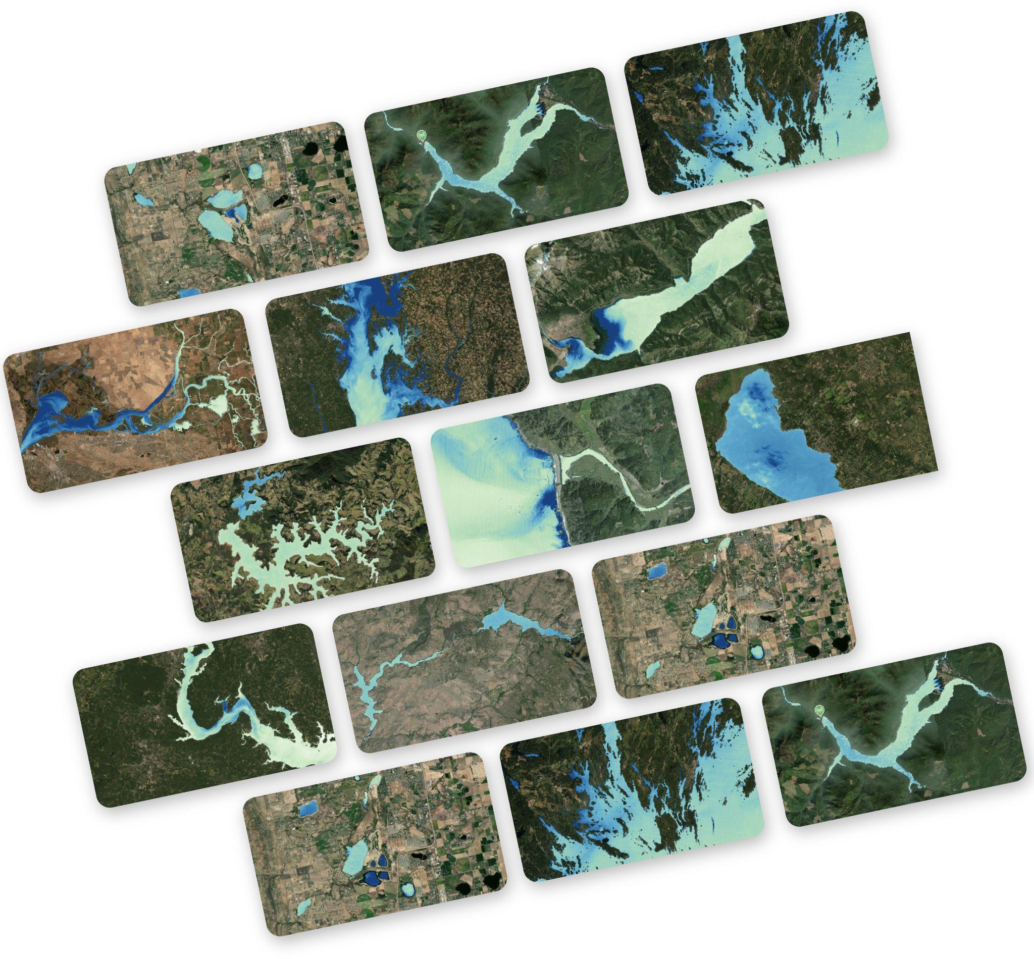
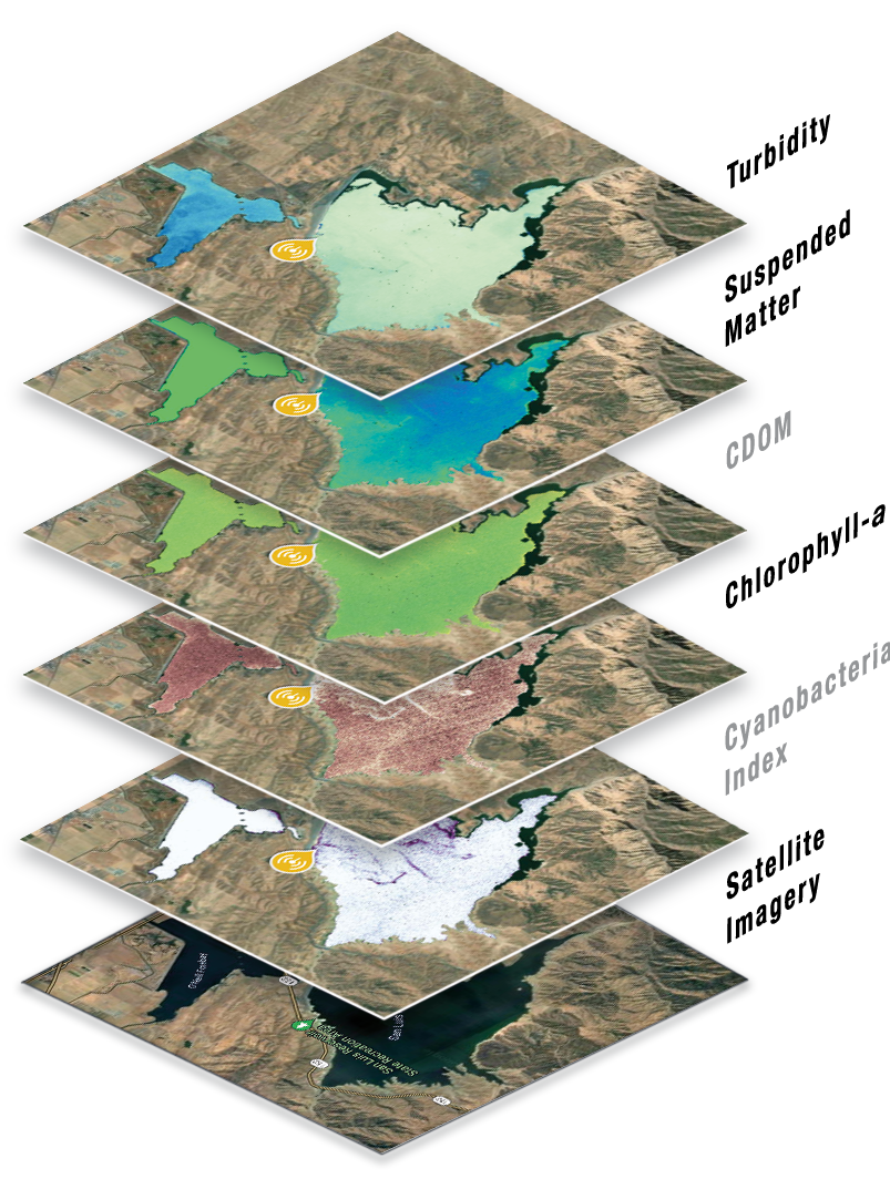
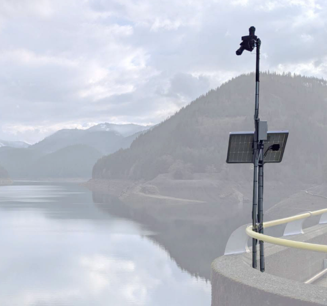
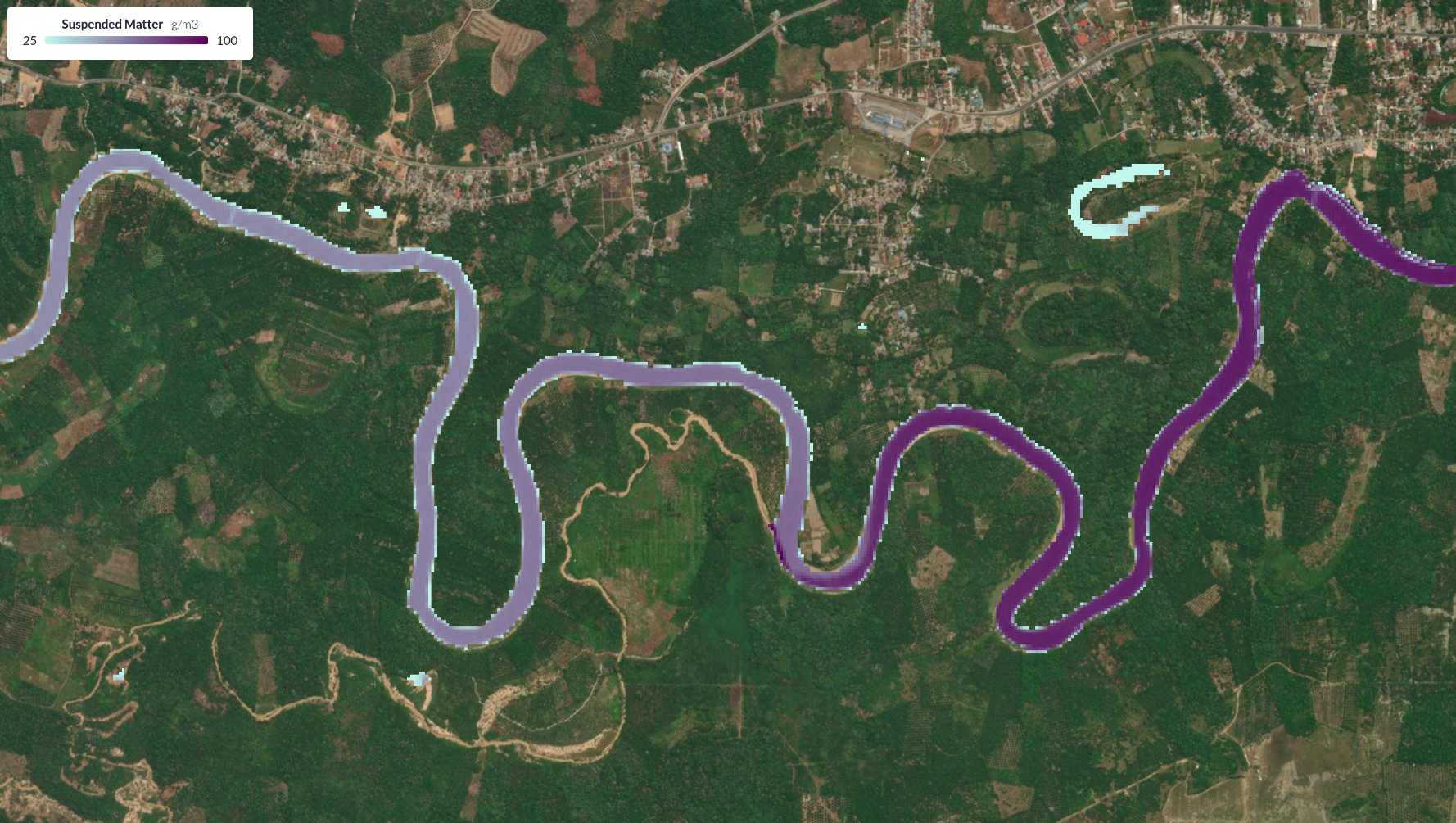
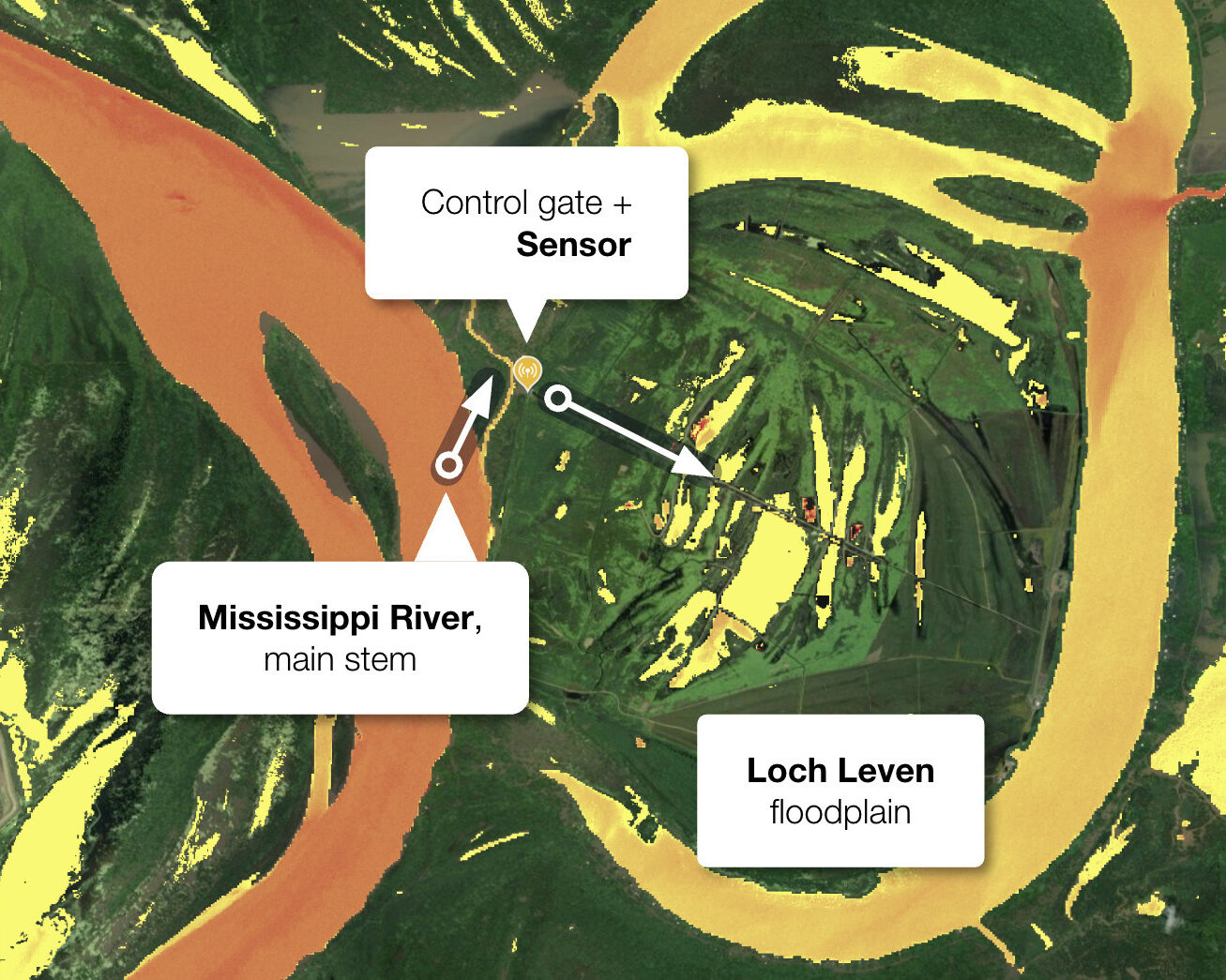
Satellite observations, on-the-ground sensors, and environmental
big-data analysis — brought to bear on your specific water quality
challenge.
Built by water quality experts, with a portfolio spanning NGOs,
restoration companies, utilities, and research institutions across the
globe.
Basin-scale water intelligence — continuous, spatially explicit, actionable — barely exists. Continuous measurements are rare and field grab sampling is periodic. Satellite observations of water bodies are two dimensional snapshots of three dimensional systems, and thus often hard to interpret. When decisions about dam removal, pollution attribution, or nutrient management are made on inadequate data — or incorrect interpretation, the consequences are real. We built the methodology and tools to close that gap.
We engage on specific problems — bring us your data challenge and we'll scope the right combination of capabilities.
We derive water quality parameters from all relevant satellite offerings (e.g. Sentinel 2 and 3, Landsat 8/9, Planet SuperDoves, etc.) using physics-based algorithms validated against in-situ measurements. Several new sensors are getting into orbit these days, which we add to our belt as required, including hyperspectral offerings.
Proprietary hyperspectral sensors (288 bands, 350–950 nm), solar-capable and maintenance-free for 6–12 months. We also work with pre-existing and off-the-shelf instrumentation. We deploy sensor networks for ground-truthing, continuous in-situ monitoring, and satellite algorithm calibration.
Large-scale environmental data analysis: pollution source attribution, sediment dynamics, nutrient sinks/sources, bloom prediction. We deliver findings in the format that works for your team — from technical reports to interactive spatial dashboards.
Each project was a distinct problem requiring satellite analysis, in-situ measurement, and scientific interpretation. Here's what they looked like.
Lower Mississippi, USA
Daily nutrient estimates for water entering, residing in, and leaving the Loch Leven floodplain. Demonstrated that in-situ monitoring alone is insufficient to track basin-wide nutrient uptake and release — satellite data fills the gaps.
Batanghari River Basin, Indonesia
Nine years of satellite data used to attribute rising sediment loads to specific mining tributaries across the Tebo and Tembesi sub-basins — tracking pollution from source to the Batang Hari.
Klamath River, USA (CA/OR)
Turbidity monitoring during the largest dam removal in US history. Continuous satellite tracking of sediment plume dynamics across the entire basin throughout the post-drawdown period.
Mississippi River Basin, USA
Basin-wide nitrate monitoring across 200 km of the lower Mississippi and Atchafalaya rivers. Scaling from isolated gauge stations to continuous, spatially explicit water quality coverage.
Organizations we've worked with
Our expertise is grounded in decades of scientific research and hands-on experience with rivers, lakes, and reservoirs across the globe, spanning water quality remote sensing, environmental data analysis, and in situ IoT instrumentation.
Our joint story began at Gybe, founded in 2019 to deliver comprehensive water pollution insights to a wide range of customers — utilities, food & beverage companies, NGOs, restoration firms, national agencies, and research institutions.
Early 2026, Nick and Phil launched Aqualytics. Where Gybe took a product-first approach, Aqualytics operates as a consultant collective — getting deep into each customer's specific challenges and delivering tailored solutions that create real, measurable impact.
Physicist and expert on water quality monitoring from space and on the ground. Optical instrument designer with a hyperspectral mindset. Bridges cutting-edge research and product mindset across multiple startups. Former CTO at Gybe.
Physicist and recognised expert in water quality monitoring. Led multiple technology spin-outs from HP Labs, Los Alamos National Labs, Bell Labs, and Oxford University. Former Chief Scientist at Gybe.
We want to grow the collective! If your skills match or complement ours, or if you would like to explore adjacent ideas — get in touch.
Whether you're exploring the technology, designing a basin monitoring program, need historical satellite analysis, or want to understand a pollution event — we'll tell you what's tractable and what it would take.
Or reach us directly at info@aqualytics.eco